Grayways (click map to view routes)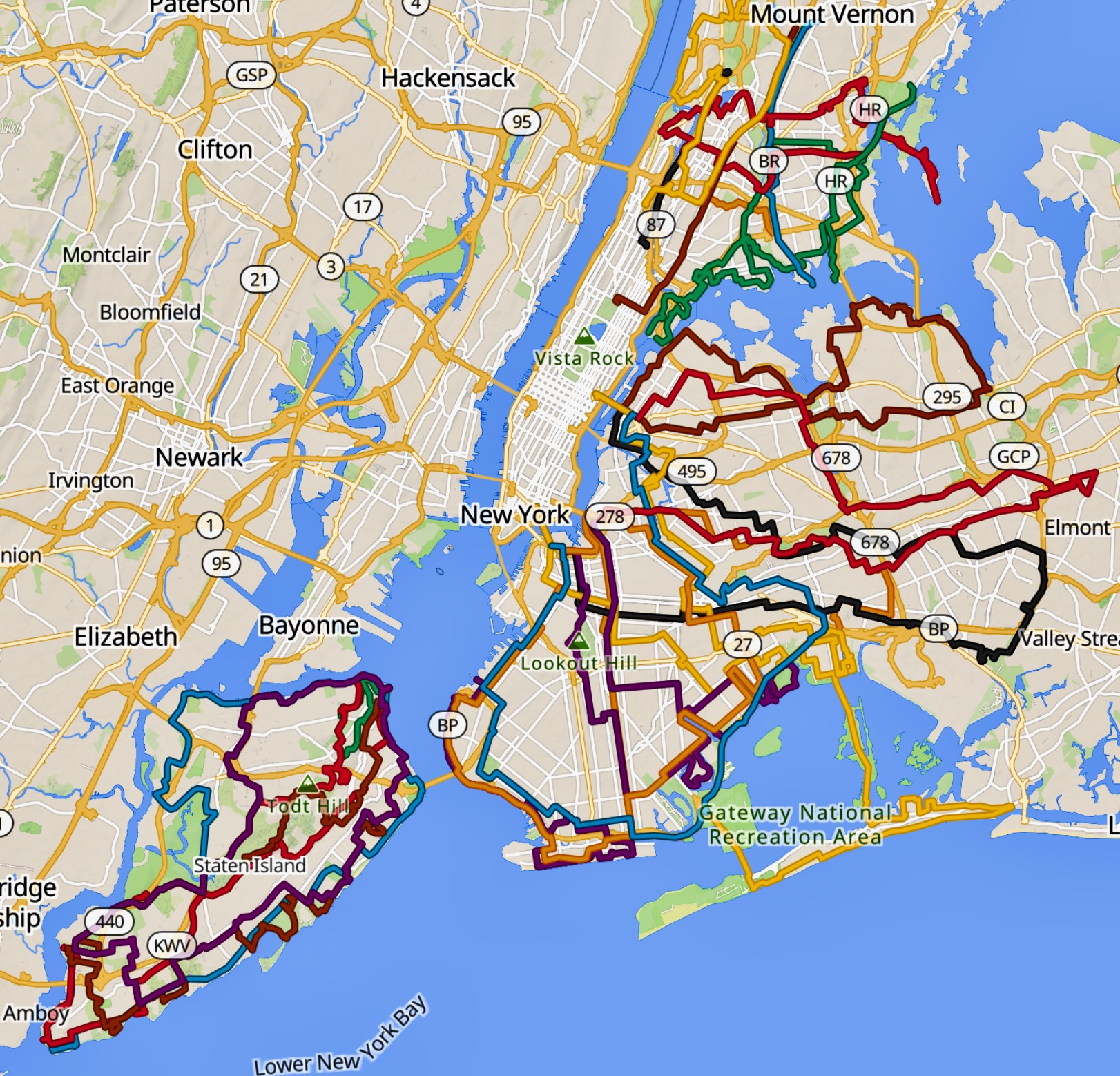 “A great bike network is made up of great bike routes.” — League of American Bicyclists
Why We Need This
New York City has spent decades—and billions—building bike lanes. Yet for many riders, the experience remains fragmented: a protected lane here, a painted stripe there, too often ending at a stressful arterial or a crowded park drive. The result is a bike network that exists mostly in pieces, not as a coherent whole. Grayways offers a simple, practical fix.
Overview
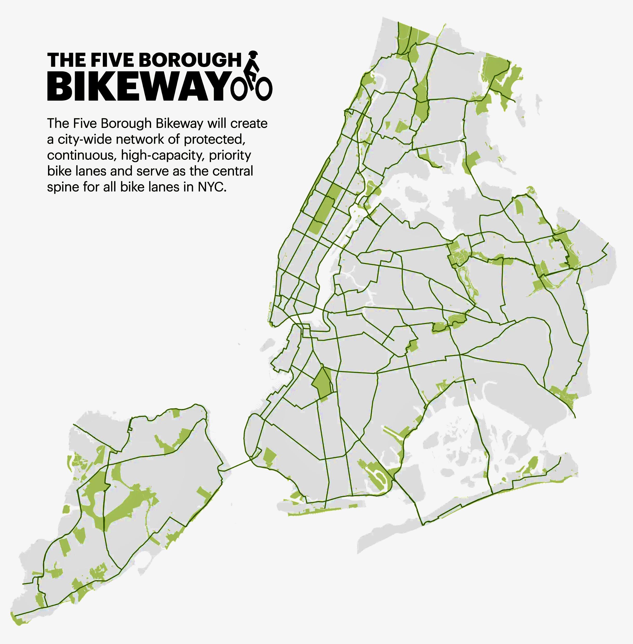
Grayways is a proposal calling on the NYC Departments of Transportation and Parks & Recreation to designate a 500 mile recreational weekend bike network that connects parks, neighborhoods, and transit hubs across the city. Instead of starting from scratch, it stitches together what New York already has: existing bike lanes, quiet residential streets, lightly used commercial areas, and park connections.
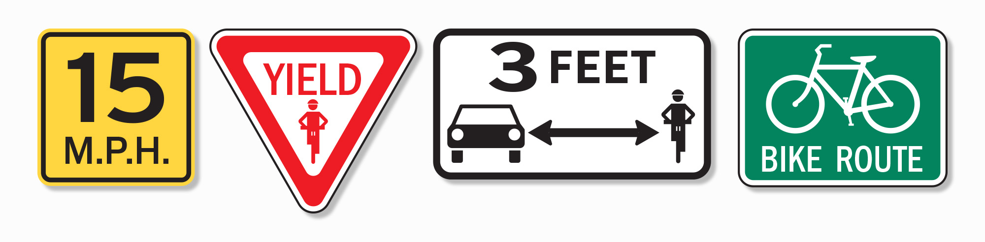
The concept is adapts the East Coast Greenway model by mapping the entire network, through bike-friendly legislation and GPS wayfinding.
• Routes would be GPS-mapped and recognized as official NYC bikeways.
• Speed limits for all vehicles would be capped at 15 mph.
• Cyclists could yield at stop signs, and
• Three-foot safe-passing standard would apply.
These are not radical ideas; they are widely used tools that calm traffic, improve safety, and make streets more accessible for everyone.
 MUTCD, Joe Lertola.
The initial network proposes 23 routes spanning the Bronx, Brooklyn, Queens, and Staten Island. They range from seven to 47 miles, averaging about 28 miles—long enough to feel like a destination, not just a commute.
They mostly avoid already overcrowded facilities like Central and Prospect Park Drives, the Hudson Greenway, and the Coney Island and FDR boardwalks. Instead, they unlock underused streets and neighborhoods, feature local food stops, leverage ferries and subways, and incorporate playgrounds as regular rest stops—ideal locations for bike-share docking and, eventually, e-bike charging.
Easy to Jump-Start
The first iteration could be launched almost immediately by publishing GPS routes on NYC.gov. That alone would benefit New Yorkers who already cycle and are comfortable riding in city traffic. As routes gain acceptance, targeted upgrades would follow, expanding access to a greater percentage of city residents.
 Alta Planning + Design.
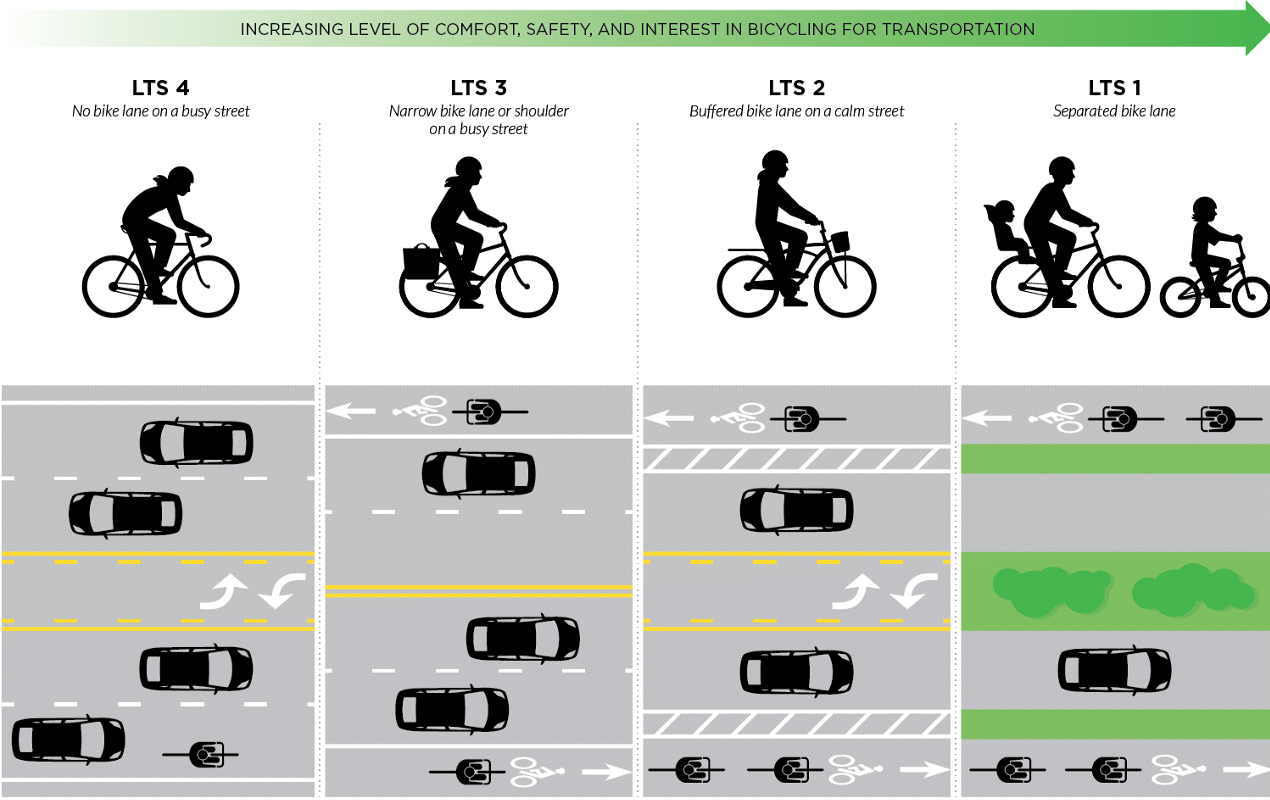
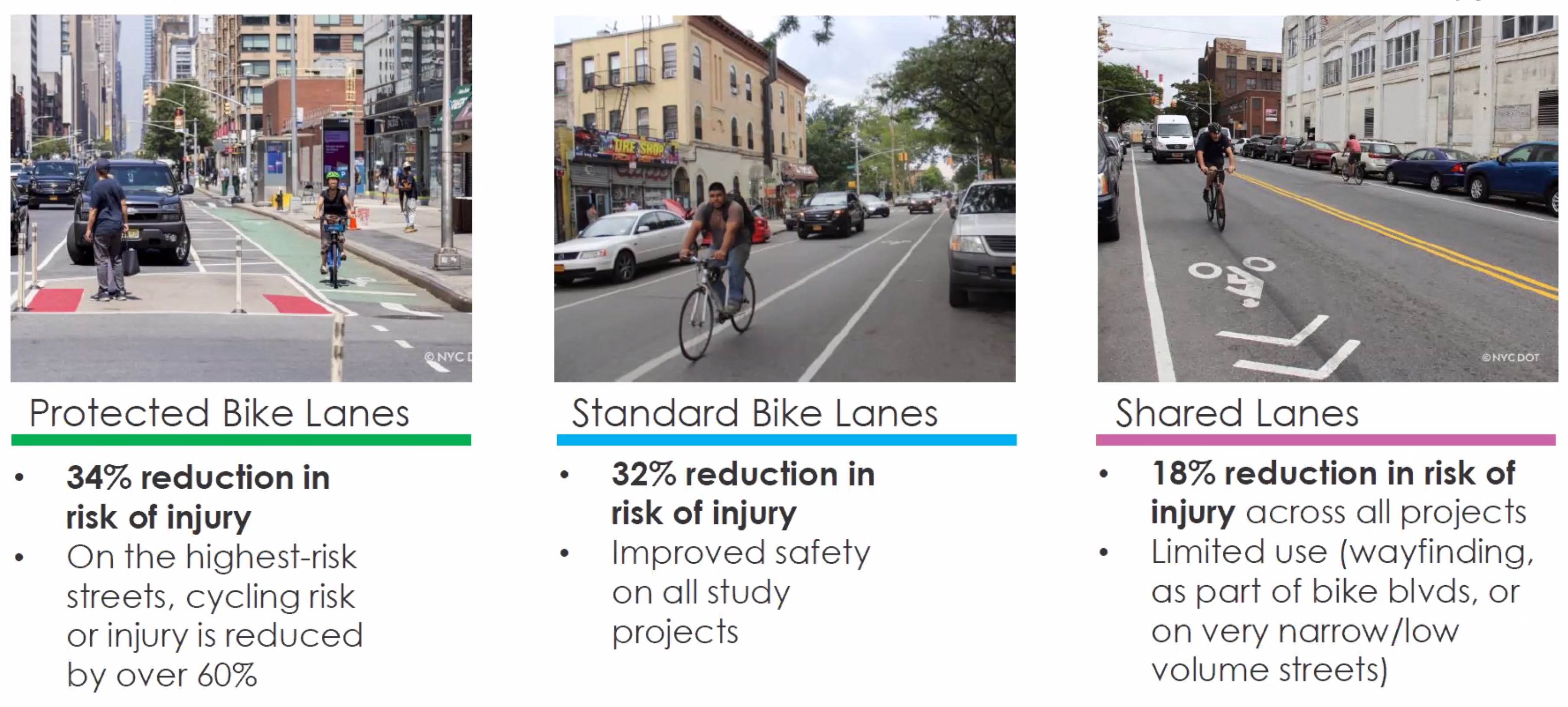
Cheaper to Upgrade
This incremental approach is also fiscally smart. NYCDOT’s own data shows that adding a standard bike lane to a low-stress road achieves nearly the same harm reduction as building a fully protected lane on a high-stress road.
A network built around calmer streets is cheaper to implement and easier to improve over time. Crowd-sourcing priorities, integrating new DOT projects as they come online, adding leading pedestrian intervals at signals, and designating bicycle cut-throughs are all proven, low-cost strategies.
 New York City Department of Transportation.
Make it Fun!
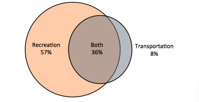
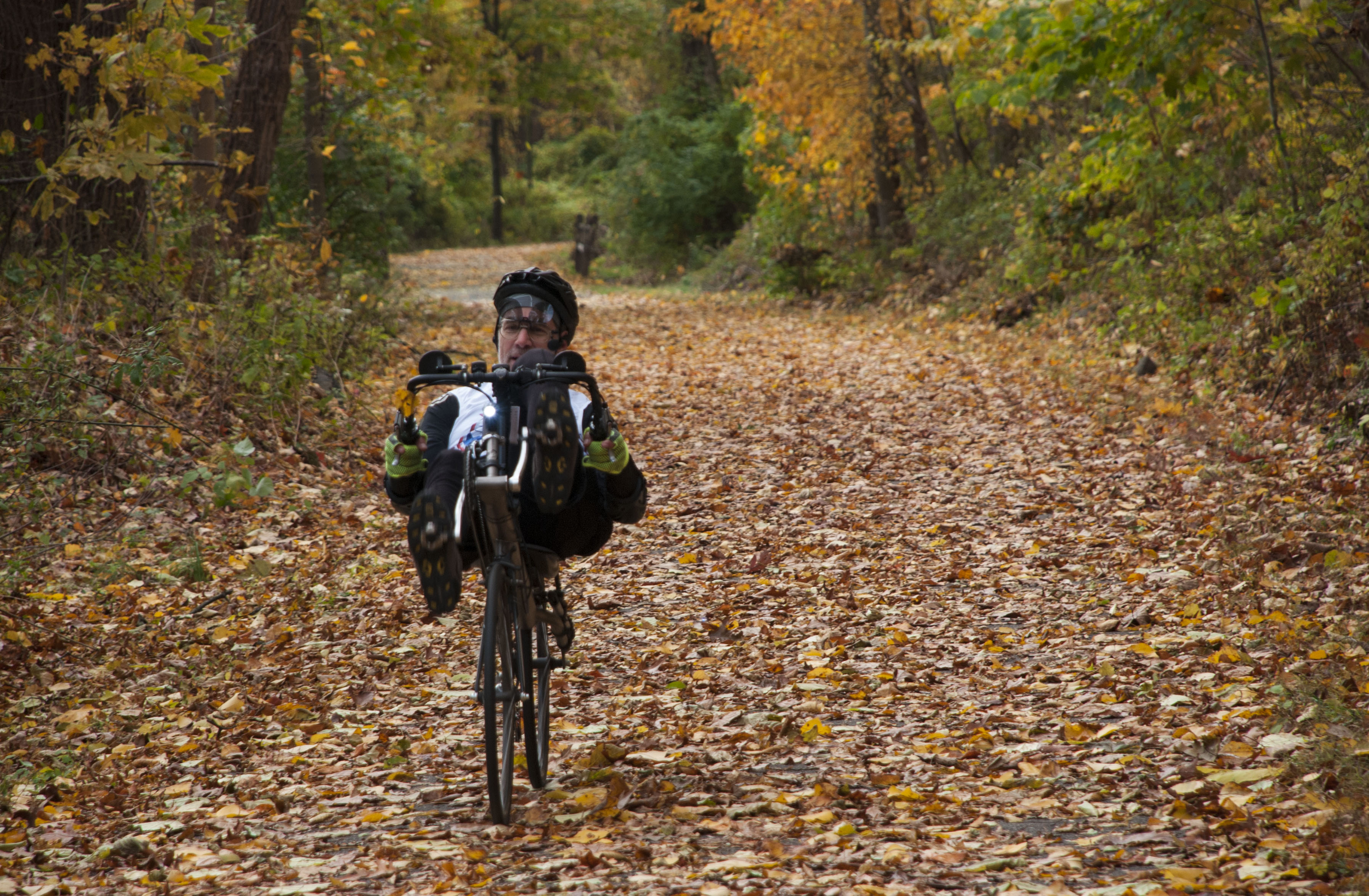
Why does this matter? Because most people bike for recreation, not commuting. Nationally, twice as many ride for fun as for transportation. In New York, state and city surveys show strong interest in bike tourism and recreational riding—especially trips that feel safe, scenic, and connected. If the city wants more people on bikes, it should design for how people actually ride.
The NYSERDA-Urban Cycling Solutions NY Cycling Census, found that “a third of respondents currently use their bikes for tourism purposes and that most are very likely to.”
 “U.S. Bicycling Participation Benchmarking Study, 2015, People for Bikes (p.22)
Extend Access to Green Space
Grayways would dramatically expand access to green space. It supports Parks & Recreation’s Walk to a Park goal by making far-flung parks—like Shirley Chisholm State Park or Orchard Beach—reachable without a car.
It advances the vision of Parks Without Borders by treating the journey itself as part of the park experience.
And by shifting recreational cycling away from already saturated routes like Central and Prospect Parks and Hudson Greenway, it would ease crowding during peak weekends and holidays.
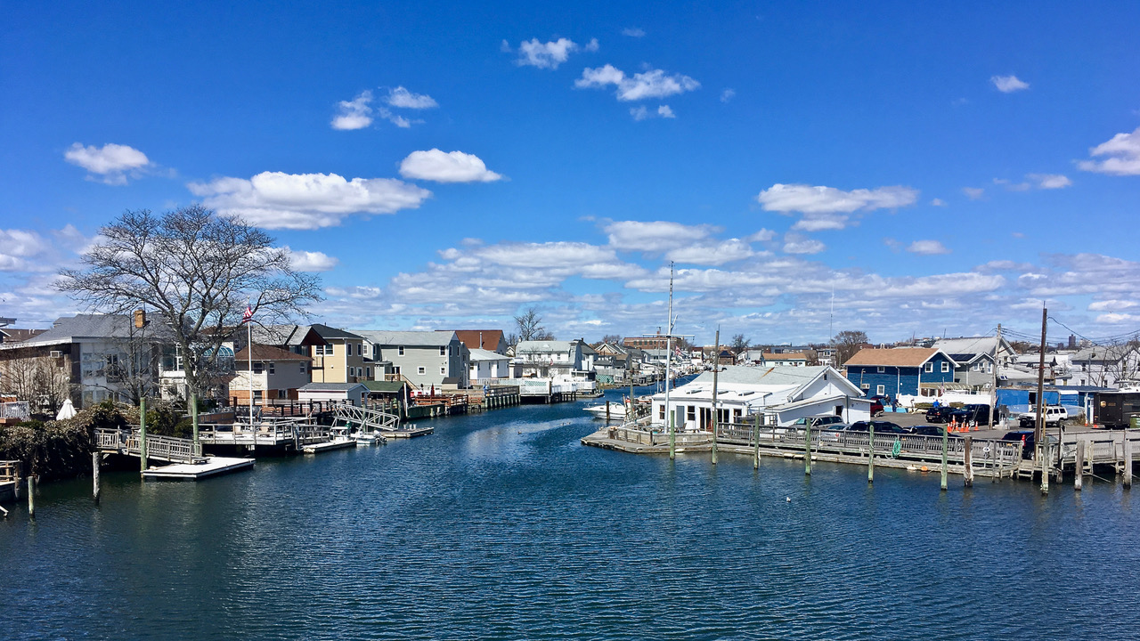 Hamilton Beach
Benefit Underserved Constituencies
The equity benefits are just as compelling. A citywide recreational network would bring safe exercise and low-cost mobility to neighborhoods with limited access to green space. It would help bridge transportation deserts, reduce household travel costs, and strengthen the “safety in numbers” effect that makes cycling safer as participation grows.
It would also give bike-share providers a clear roadmap for expanding service into the outer boroughs—and give bridge operators a renewed incentive to finally provide bike access across the city’s major crossings.
Create Jobs, Develop Local Economies
There is also real economic upside. Cycle tourism contributed $83 billion annually in direct spending to the U.S. economy. Even a modest share of that activity represents hundreds of millions of dollars annually for New York City.
Studies consistently show that proximity to bikeways increases property values, and local bike shops are heavily dependent heavily on recreational riders.
Reduce Greenhouse Emissions
Grayways is a climate and resilience strategy. Encouraging recreational trips by bike reduces vehicle miles traveled, including trips that would otherwise be taken in electric cars. It strengthens multimodal travel by extending the reach of subways, buses, and ferries.
Enhance Resilience
In an era of extreme weather, pandemics, and infrastructure failures, a connected bike network provides critical redundancy when other systems are stressed.
New York does not need another bike lane to nowhere. It needs a network that makes sense—one that invites people to ride, explore, and connect. Grayways offers exactly that: a fast, affordable way to turn scattered infrastructure into a citywide asset.
The streets are already there. It’s time to connect them.
 Brookville Park
Resources
Grayways (Old), draft NYC Council bill and resolution
Urban – Transport for London Strategic Cycling Analysis, Regional Plan Association Jamaica Bay Greenway, 1997 NYC Bicycle Master Plan, Brooklyn Greenway Initiative—Greenway Adventures, San Francisco Slow Streets, NYC Council Intro 0291-2022 – CityWide Greenway Bill, 34th Avenue Open Street, Chicago Cycling Plan 2020, Benching Bike Networks, League of American Bicyclists
Suburban – Somerset (NJ) Walk-Bike-Hike, Bergen (NJ) Parks Master Plan, Suffolk County Hike And Bike Master Plan, Bike Hunterdon
Rural – Small and Rural Multimodal Networks, USDOT-FHWA
Scenic Roads – CT Scenic Roads, NY Scenic Byways, Taste NY Cuisine and Beverage Trails
Extended Routes – U.S. Bicycle Route System, NY Bicycle Route System, NY BR Viewer, Old Croton Aqueduct State Park, Empire State Trail, High Point (NJ) to Cape May Bike Route, East Coast Greenway, RPA Tri-State Trail Network, LAB Benchmarking Bike Networks
Neile Weissman heads up Complete George, which was formed in 2013 to advocate for modern bikeways across the George Washington Bridge. We continue to call for laws and infrastructure that support the growth of cycling.
 North-South County Trailway. Image Alex Lektchinov.
